

Abbot Point State Development Area
Declared in 2008, the 16,885-hectare Abbot Point State Development Area (SDA) is located approximately 20 kilometres north-west of Bowen, in North Queensland.
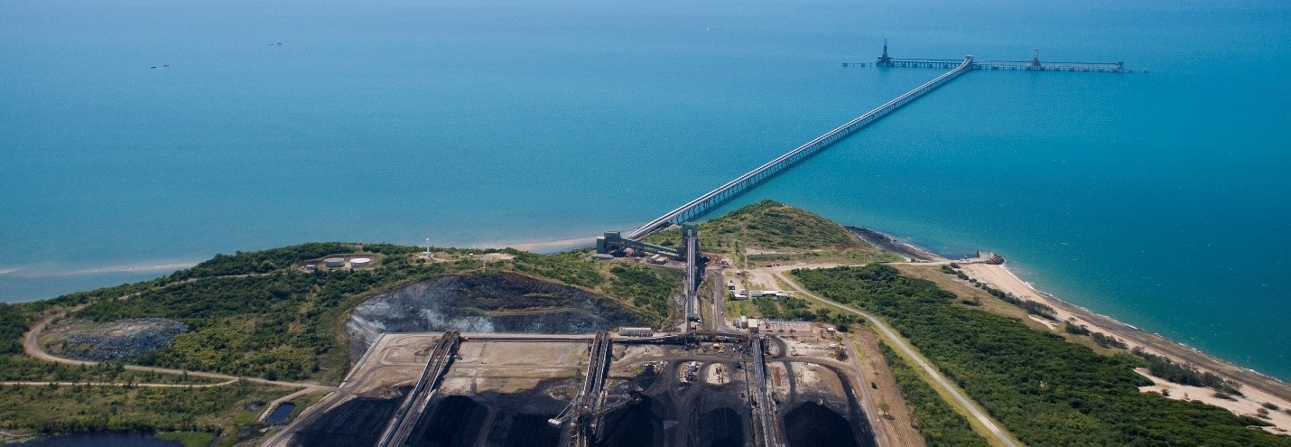
The Abbot Point SDA offers the ideal location for industrial and port-related development that requires a large footprint, proximity to a port and separation from sensitive receptors.
Opportunity awaits
The Abbot Point SDA was established to facilitate large-scale industrial and port-related development of regional, state and national significance.
Adjacent to the Abbot Point SDA is the Port of Abbot Point; one of Queensland's priority ports. The Port of Abbot Point currently has a coal export capacity of 50 million tonnes per annum. It comprises rail in-loading facilities, coal handling and stockpiling areas and a single trestle jetty and conveyor connecting to two offshore berths and two ship-loaders which are located 2.8 kilometres offshore.
Industries considered suitable for the Abbot Point SDA include:
- large-scale, value-adding industrial development
- bulk mineral resource unloading and stockpiling facilities
- mineral processing
- integrated steel mill
- liquefied natural gas (LNG) facility
- fuel storage and associated infrastructure
- extractive industries.
Benefits of the Abbot Point SDA
The Abbot Point SDA provides many benefits to business and industry seeking to invest in Queensland including:
- close proximity to the Port of Abbot Point
- easy access to rail and roads, including the Bruce Highway
- considerable distance from urban areas
- greater planning and development certainty for project proponents
- fast-tracking economic development through efficient processing of applications and requests
- best practice land-use planning and management – ensuring land and infrastructure assets remain attractive to existing occupants and potential investors
- some of the land within the SDA is within state ownership (owned by either the Coordinator-General or the Minister for Economic Development Queensland)
- access to a diverse skilled workforce within the town of Bowen, located directly south-east of the SDA
- concentration of industrial development in selected areas, thereby minimising or avoiding:
- environmental impacts
- loss of amenity
- infrastructure duplications
- transport conflicts.
Managed by the Coordinator-General, the Abbot Point SDA supports enterprise and job creation in a way that considers environmental, cultural, and social issues as well as existing industry and surrounding infrastructure within the region.
A significant portion of land within the Abbot Point SDA is owned by the state government. The Coordinator-General owns approximately 3322 hectares of land. The Minister for Economic Development Queensland (EDQ) owns approximately 6328 hectares of land. View the land ownership map (![]() 354 KB).
354 KB).
-
The Abbot Point State Development Area Development Scheme (
 3.1 MB) is a regulatory document that controls planning and development within the Abbot Point SDA. It was first approved by the Governor in Council in June 2008.
The development scheme contains a development assessment framework for making, assessing and deciding applications and requests relating to development within the Abbot Point SDA, predominately land use, operational work and reconfiguring a lot.
The development scheme is supported by a public consultation policy (
65 KB) that provides information on matters the Coordinator-General may consider when determining whether public consultation of an SDA application is required. -
The Abbot Point SDA regulation map (
1.2 MB) defines the boundary of the declared Abbot Point SDA.The Abbot Point SDA designation map (
512 KB) identifies those parts of the Abbot Point SDA considered broadly suitable for various types of industrial and infrastructure development. The map forms part of the development scheme.There are six precincts within the Abbot Point SDA:
- Industry Precinct
- Infrastructure and Corridors Precinct
- Restricted Development Precinct
- Environmental Management / Materials Transportation Precinct
- Port Facilities Precinct
- Port Expansion Precinct
The preferred development intent for each precinct is outlined in the development scheme. Each precinct description is followed by a table which identifies regulated development in the relevant precinct.
-
The Abbot Point SDA has been amended numerous times.
Previous versions of the development scheme are available:
- Development Scheme for the Abbot Point State Development Area (September 2012) ( 300 KB)
- Development Scheme for the Abbot Point State Development Area (June 2008) ( 208 KB)
Previous maps are also available:
- Development Scheme for the Abbot Point State Development Area (September 2012) (
-
A significant portion of land within the Abbot Point SDA is owned by the state government. The Coordinator-General owns approximately 3322 hectares of land. The Minister for Economic Development Queensland (EDQ) owns approximately 6328 hectares of land. View the land ownership map (
354 KB).The Coordinator-General's land holdings include land for multi-user infrastructure corridors, industrial development and buffer areas. For more information on the land owned by the Coordinator-General contact the Office of the Coordinator-General on 1800 001 048 or via sdainfo@coordinatorgeneral.qld.gov.au.
Visit the EDQ Industrial Development website to view industrial land available for sale and lease within the Abbot Point SDA from the Minister for Economic Development Queensland.
Further information
For further information on the Abbot Point SDA contact the Office of the Coordinator-General on 1800 001 048 or via sdainfo@coordinatorgeneral.qld.gov.au
Last updated: 16 Mar 2023